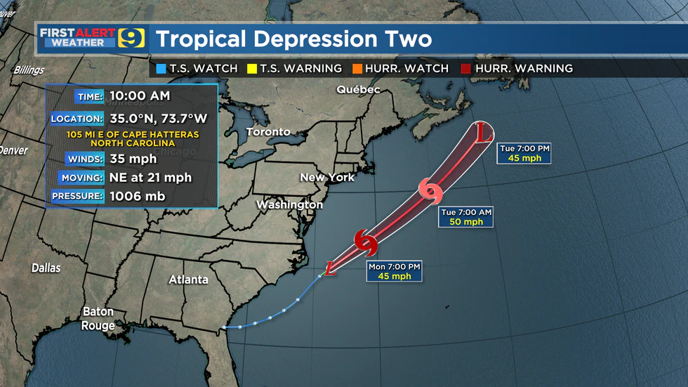
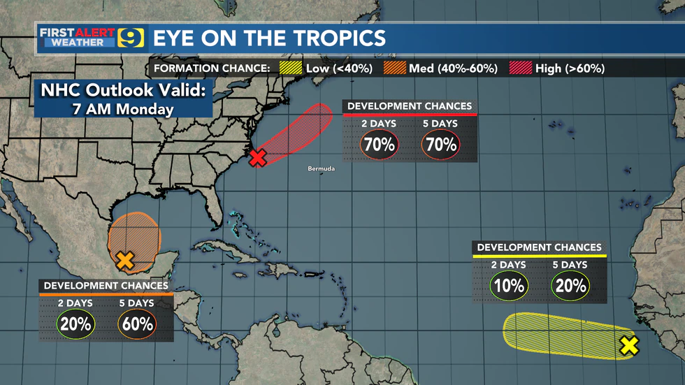
BATON ROUGE, La. (WAFB) – The tropics are unusually active for the mid part of June. The National Hurricane Center (NHC) began issuing advisories on Tropical Depression #2, located off the coast of North Carolina, at 10 a.m. Monday morning. Forecasters at NHC are highlighting two additional areas of potential development in the southern Gulf of Mexico and in the far eastern Atlantic near the western coast of Africa.
Tropical Depression #2 originated as a non-tropical area of low pressure along a front in the western Atlantic. The warmer waters of the Gulf Stream seem to have given it the quick boost it needed to transition into a tropical system. While it’s forecast to become Tropical Storm Bill by late Monday, the good news is it will be moving away from the U.S. East Coast and is unlikely to directly impact land.
Closer to home, our focus will remain on the Gulf of Mexico throughout the week. NHC is monitoring an area of disturbed weather in the Bay of Campeche, giving it only a 20% chance of development over the next 2 days, but a 60% chance over the next 5 days. The disturbance is likely to meander through midweek before eventually moving northward by late in the week. At this point, guidance doesn’t really show anything stronger than a tropical storm developing, but the intensity may not be the big story.
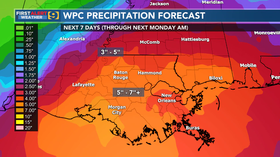
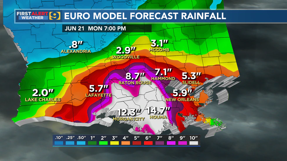
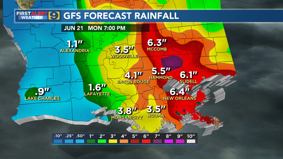
Rainfall appears to be the primary concern from whatever comes of the Gulf system. Model guidance has been very inconsistent from run-to-run over the last few days in pinpointing the location of heaviest rains but has been fairly consistent in showing some part of the northern Gulf Coast getting very heavy rainfall by the weekend. The rainfall outlook from NOAA’s Weather Prediction Center (WPC) as of Monday morning shows south Louisiana very much in play for the heavy rain. The outlook suggests rains of 5″-7″+ will be possible across much of south Louisiana over the next 7 days, with most of that expected over the weekend. But it needs to be emphasized that confidence is still somewhat low on the location of heaviest rains. We should be prepared for that potential (or worse), but also understand that things could still change quite a bit in the days ahead.
Finally, NHC is now giving a tropical wave that has emerged from Africa a 20% chance of development over the next 5 days. Development in this part of the Atlantic would be extremely unusual this early in the season. Indeed, the 20% development odds seem to be a reflection of more hostile conditions expected ahead of that disturbance.
Click here to report a typo.
Copyright 2021 WAFB. All rights reserved.