
- A tropical depression or storm is likely to form in the western Gulf of Mexico late Thursday or Friday.
- This system will bring a threat of heavy rain and possible flooding to the northern Gulf Coast this weekend.
- Coastal flooding, high surf and rip currents will also be threats at the coast.
A tropical depression or storm is likely to form in the western Gulf of Mexico later this week, and no matter how well organized this system becomes, it poses a threat of flooding rain along a part of the northern U.S. Gulf Coast heading into Father’s Day weekend. This system could also contribute to coastal flooding, dangerous rip currents and gusty winds.
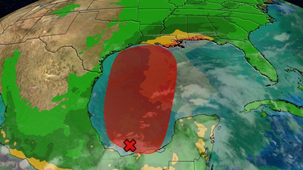
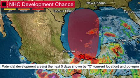
The National Hurricane Center (NHC) says there is a high chance of a tropical depression forming in the western Gulf of Mexico by late Thursday or Friday, somewhere within the red-shaded area depicted in the map below. For now, this potential system has been tagged Invest 92L, which is a naming convention used by NHC to track disturbances being monitored for the possible development into a tropical depression or storm.
(MORE: What is an Invest?)
Claudette will be the name given to the next tropical storm that forms in the Atlantic.
Potential NHC Development
(The potential area(s) of tropical development according to the latest National Hurricane Center outlook are shown by polygons, color-coded by the chance of development over the next five days. An “X” indicates the location of a current disturbance.)
Invest 92L is currently a broad area of low pressure in the southwest Gulf of Mexico, or Bay of Campeche, that’s producing disorganized showers and thunderstorms. Rainfall in that region could trigger flooding in parts of southern Mexico.
Computer forecast models have been consistently suggesting over the past several days that low pressure may become better defined as Invest 92L gets drawn northward through the western Gulf of Mexico later Thursday into Friday.
Shop Top Gifts For Dad at The Home Depot (SPONSORED)
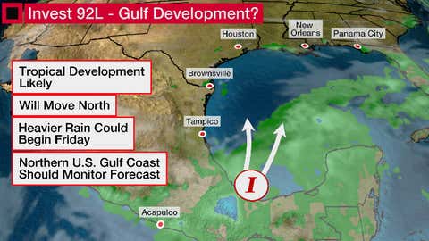
Unfavorable upper-level winds (wind shear) and dry air are two factors that should prevent this system from intensifying quickly. Those factors will also keep most of the impacts from this system in areas near and well to the east of where its center of circulation tracks.
The majority of computer model guidance suggests the center of this system will move inland on the northern or western Gulf Coast early this weekend. Impacts like rainfall, higher than normal tides and rip currents could arrive on the northern Gulf Coast as soon as late this week.
Here’s what we know right now about the potential threats.
Forecast Impacts
Rainfall Flood Threat
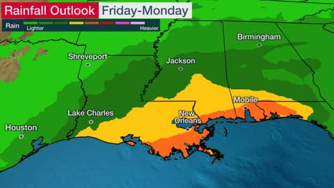
Regardless of the exact track or strength of this system, we expect heavy rain along the northern Gulf Coast beginning as soon as Friday and lingering into the weekend. This includes already soaked parts of Louisiana and the lower Mississippi Valley.
Our long-range rainfall outlook shows the potential for multi-inch rainfall totals this weekend from parts of southern Louisiana into southern Mississippi, southern Alabama and the western Florida Panhandle. This threat could be in play no matter how much this potential future western Gulf system organizes.
Rainfall potential depends largely on how fast, or slow, a storm moves. It doesn’t matter how strong a tropical system’s winds become.
Be Prepared For Any Storm With These Top-Rated Generators (SPONSORED)
Some locally heavy rain could even linger in parts of the Southeast Monday as the remnant is pulled east ahead of a strong cold front arriving from the central U.S.
It’s too early to pinpoint exactly what areas might see flooding this weekend, but residents along the northern U.S. Gulf Coast should continue to monitor the forecast closely.
)
Coastal Threats
Coastal flooding will be another potential impact, especially in vulnerable areas, from Louisiana to potentially as far east as the Florida Panhandle late this week into the weekend.
High surf and dangerous rip currents will also be concerns in this same general area during that time, and beachgoers are advised to stay out of the ocean.
Wind, Tornado Threats
Gusty winds will accompany this system Friday into the weekend on the northern Gulf Coast.
There could be an isolated tornado threat as soon as Friday from the far upper Texas Coast into southern Louisiana.
June Gulf Storms
June storms in the Gulf of Mexico are fairly typical.
Since 2000, there have 16 named storms in the Gulf of Mexico. Eleven of those made a U.S. landfall.
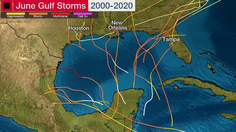
Tracks of all June Gulf of Mexico named storms from 2000 through 2020.
(Data: NOAA/NHC)
The most recent one was last year. Tropical Storm Cristobal formed from the remnant of eastern Pacific Tropical Storm Amanda, then made landfall in southeast Louisiana.
Other June Gulf storms were prolific flood producers, including Debby in 2012 in Florida and Allison’s $9 billion flood in 2001 in Houston.
The last June Gulf hurricane was in 2010.
Hurricane Alex made a Category 2 landfall in northeast Mexico triggered massive flooding in Monterrey, Mexico, where up to 35 inches of rain fell.
June Gulf U.S. hurricane landfalls are extremely rare. The last one was Hurricane Bonnie, 35 years ago.
The Weather Company’s primary journalistic mission is to report on breaking weather news, the environment and the importance of science to our lives. This story does not necessarily represent the position of our parent company, IBM.