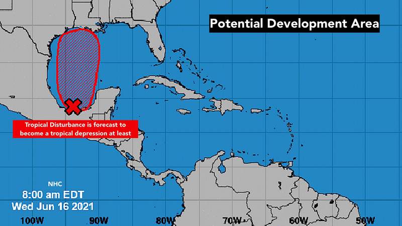
The disturbance in the extreme southwest Gulf of Mexico is still broad and disorganized. All indications are that it will lift away from the Mexican coast beginning tomorrow, however. The steering flow will increase and push the system to the north toward the east Texas, Louisiana, and/or Mississippi coast.
The gusty winds and heavy rain will arrive at the coast ahead of the center of the system – likely on Friday.
Disorganized, just-developing, and slow-moving systems are always poorly forecast by the computer models, so the details of exactly what’s going to evolve are unknown, including precisely where the heaviest rain and gustiest winds will occur. But in broad strokes, the forecast looks logical.
The nose of the big high-pressure system over the Atlantic has been pushed the south and east the last few days. That has put a southwest wind flow over South Florida, which has resulted in very heavy thunderstorms moving across the Miami-Fort Lauderdale area from the Everglades.
Ad
The lack of steering winds has also left the tropical disturbance stranded in the extreme southwestern Gulf of Mexico. Even though the upper winds have been conducive for organization, a good part of the broad circulation is over land, so the system remains messy.
Beginning tomorrow, however, the nose of the big high will push back over Florida and the Gulf. That should begin to lift the disturbance north, and slowly limit the thunderstorm activity over the southern Florida peninsula.
With the high will come more Saharan dust. It might be enough to significantly limit thunderstorms over Florida this weekend, and it could affect the disturbance as well.
The atmospheric pattern, including the potential dust, over the Gulf does not look especially conducive for development over the next few days, so it doesn’t appear the disturbance could get terribly strong. The consensus of the computer forecast models is that at least a tropical depression will form with a chance that winds on the east side of the circulation could reach 40 mph.
Ad
The air east of the potential system will be squeezed between the low pressure of the disturbance/depression and the building high pressure over the Atlantic. This might result in a corridor of 40 mph winds or a bit higher. If that happens, the system would get a name. It would be Claudette.
The bottom line is, people on the northern Gulf coast between Texas and Alabama need to be ready for flooding rain and gusty winds at the end of the week. Some coastal flooding is possible as well where the strongest winds push onshore. The exact locations are not known at this time.
Elsewhere in the Atlantic, the systems we were watching are no longer of concern. As expected, Tropical Storm Bill got swept up into the North Atlantic to die, and Saharan dust killed off the disturbance in the eastern Atlantic. Nothing else appears in the offing for now.
Copyright 2021 by WPLG Local10.com – All rights reserved.