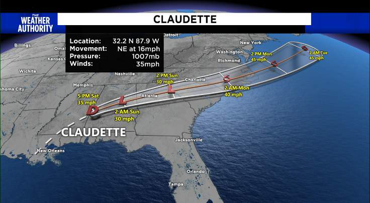
JACKSONVILLE, Fla. – At 5 p.m. Saturday, the National Hurricane Center downgraded Claudette to a Tropical Depression. Claudette is centered 95 miles north-northwest of Montgomery Alabama, and moving northeast at 16 mph. It has maximum sustained winds of 35 mph.
A Tropical Storm Warning is in effect from the Mississippi/Alabama border to the Okaloosa/Walton County line of Florida. A Tropical Storm Watch is in effect for Cape Fear to Duck, North Carolina and Pamlico and Albemarle Sounds.
Despite Claudette being a tropical depression it’s forecast to become a tropical storm again when it moves across the Carolinas Sunday night or early Monday.
It is not much to look at — broad and lopsided — which is classically the case in early season tropical systems.
Winter dry air is still mixing down deep into the tropics. Yes, it is not cold air, but it is dry air. This almost always leads to asymmetrical tropical systems.
The “wet” side is generally east of the storm track and it is in this region, where over the next 3-5 days we will see the wettest and stormiest, along with the highest winds and highest storm surge (if any, this is a weak system).
Ad
A turn toward the northeast is expected later today, followed by a motion toward the east-northeast tonight or Sunday. On the forecast track, the system should move farther inland across portions of the southeast U.S. through Sunday night, and over the western Atlantic Ocean on Monday.
Although the track of this system will be well west of Jacksonville, we will be on the eastern (wetter) side.
By Monday and Tuesday, after this system moved ashore and moves toward Atlanta, we will begin to feel some of the fringe effects of the tropical system. Basically, the threat of heavy rains will be widespread across the Southeast United States.
TRACK THE TROPICS: Interactive map from The Weather Authority
More from the National Hurricane Center:
HAZARDS AFFECTING LAND
RAINFALL: Claudette is expected to produce additional rainfall totals of 3 to 6 inches with isolated maximum amounts of 8 inches across eastern Alabama, northern Georgia, the Florida Panhandle, and South and North Carolina. Flash, urban and small stream flooding impacts as well as new and renewed minor to isolated moderate river flooding are likely across these areas. The storm total rainfall is expected to be 5 to 10 inches with isolated 15 inch totals in southeast Louisiana, southern Mississippi, southern Alabama, and the western Florida panhandle.
Ad
STORM SURGE: The combination of storm surge and the tide will cause normally dry areas near the coast to be flooded by rising waters moving inland from the shoreline. The water could reach the following heights above ground somewhere in the indicated areas if the peak surge occurs at the time of high tide… Cape Lookout, NC to NC/VA Border…1-3 ft Surge-related flooding depends on the relative timing of the surge and the tidal cycle, and can vary greatly over short distances. For information specific to your area, please see products issued by your local National Weather Service forecast office.
WIND: Tropical storm conditions are possible in the watch area Sunday night and Monday.
TORNADOES: A few tornadoes are possible this evening and tonight across southeast Alabama, the western Florida Panhandle, and southwest Georgia.
Copyright 2021 by WJXT News4Jax – All rights reserved.