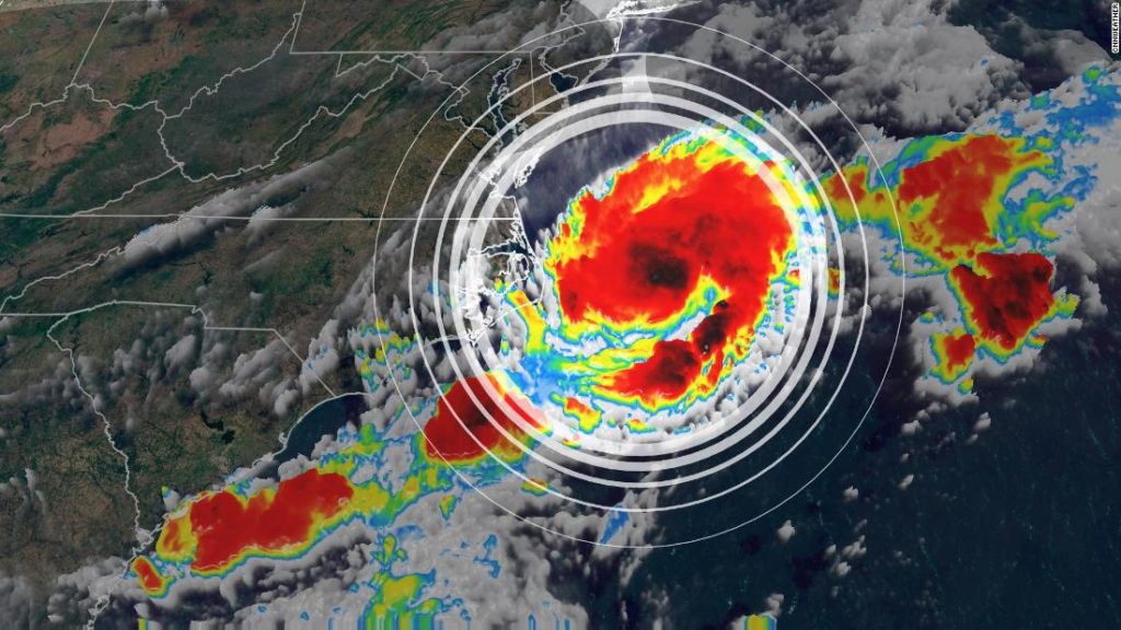
Tropical depression 2 has formed about 100 miles east of Cape Hatteras, NC. This tropical depression could become tropical storm Bill later today.
Maximum sustained winds are near 35 mph with higher gusts. “The depression is expected to become a tropical storm by tonight and could continue to strengthen on Tuesday,” the National Hurricane Center says.
Luckily, the storm will push away from the US in the days ahead, leading to some cloudiness, scattered showers and higher surf for portions of the Outer Banks.
“The system should begin to weaken by Tuesday night and is expected to dissipate on Wednesday,” the NHC says.
The system will be entering the colder water off the coast of Canada by mid-week, preventing the storm to strengthen further.
Possible development in the Gulf of Mexico

A cluster of storms in the southern Gulf of Mexico have been sitting there for several days. But weather models hint that the storms could become more organized and push into the central Gulf of Mexico.
“Some slow development of this disturbance is possible during the next few days while it meanders near the coast of Mexico,” says the NHC.
“A tropical depression could form late in the week when the system begins to move slowly northward,” says the NHC.
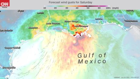
Both the American and European forecast models are hinting at a possible landfall along the central Gulf of Mexico by this weekend. However, it’s still too early to tell with certainty where this area will end up or how strong it will be.
The NHC gives this area a 20% percent chance of development in the next 48 hours and 60% chance of development in the next 5 days.
Regardless, “heavy rainfall is possible over portions of Central America and southern Mexico during the next several days,” says the NHC.
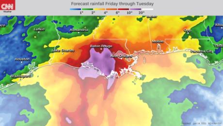
Beyond that, the focus will be concentrated along the Gulf Coast, where the storms are expected end up next. Even if the disturbance doesn’t develop into anything tropical, it could still bring a lot of rain to areas in the Gulf of Mexico that have already been soaked. This could potentially lead to more flash flooding.
A third area to watch off the coast of Africa
If two areas weren’t enough, there’s a third area to watch well out in the Atlantic. A tropical wave off the coast of Africa is producing showers and storms.
“Some development of this system is possible during the next few days before a combination of dry air aloft and strong upper-level winds limit any chance of formation while the wave is over the central tropical Atlantic Ocean late week,” says the NHC. This system has a low chance of development. The NHC gives it a 10% chance of development during the next 48 hours and a 20% chance of development during the next 5 days.
Waves off the coast of Africa certainly can impact the US, but it’s less likely this early in the season. Later in the season, wind shear is weaker in the Atlantic, which makes conditions more favorable for these waves to make the entire journey across the Atlantic Ocean.
Hurricane Season
In an average season, we see 14 named storms, 7 hurricanes and 3 major hurricanes.
Hurricane season runs from June 1 to November 30.